Veer Bharat Nyas Gives Scientific Edge to Jal Ganga Campaign
Jun 9th, 2026 6:54 pm | By ThenewsmanofIndia.com | Category: SPECIAL NEWS COVERAGE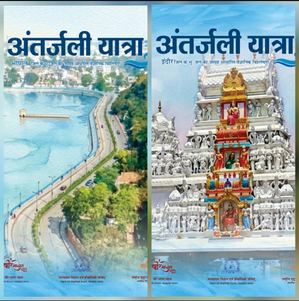
By THE NEWSMAN OF INDIA.COM|
Veer Bharat Nyas Provides Scientific Foundation to Jal Ganga Samvardhan Abhiyan Through Historic ‘Antarjali Yatra’ Initiative
Groundwater Atlas Prepared Using Advanced Remote Sensing and GIS Technologies to Strengthen Water Resource Management
Madhya Pradesh’s ambitious Jal Ganga Samvardhan Abhiyan is steadily evolving into a comprehensive model for water conservation and sustainable environmental management. While the campaign has already emerged as a people-centric movement for the revival and protection of water resources, a significant scientific dimension has now been added through the pioneering efforts of Veer Bharat Nyas and MAPCAST (Madhya Pradesh Council of Science and Technology).
In a landmark initiative, the campaign has been equipped with a robust scientific and technological framework through the preparation of the “Antarjali Yatra” Groundwater Atlas, a comprehensive scientific document based on satellite imagery and advanced geospatial technologies. Developed under the Jal Ganga Samvardhan Abhiyan 2026, the atlas is expected to transform groundwater management, water quality assessment, and long-term planning for sustainable water use across the state.
Scientific Mapping for Sustainable Water Management
To strengthen the conservation, rejuvenation, and management of water resources, MAPCAST has undertaken the preparation of a series of scientific documents and thematic atlases. Among these, the “Antarjali Yatra” Groundwater Atlas stands out as a significant achievement.
Groundwater atlases for the districts of Bhopal, Indore, Ujjain, Gwalior and Jabalpur have been prepared and made available to concerned departments. These atlases provide detailed information on groundwater availability, recharge potential and quality, enabling authorities to make informed and evidence-based decisions.
The initiative is expected to significantly enhance the effectiveness of groundwater management practices while supporting the broader objectives of water conservation and environmental sustainability.
Advanced Technology at the Core
The atlas has been developed under the technical guidance of the National Remote Sensing Centre (NRSC), ISRO, Hyderabad, utilizing state-of-the-art Remote Sensing and Geographic Information System (GIS) technologies.
The scientific study integrates advanced digital elevation models, lineament analysis and lithological data to generate detailed groundwater maps. These maps have been compiled into the “Antarjali Yatra” Atlas, creating a valuable repository of scientific information for water resource planning and management.
The atlas includes both Groundwater Potential Maps and Groundwater Quality Maps, offering a comprehensive understanding of groundwater conditions across different regions.
Supporting Public Health Through Water Quality Assessment
One of the most significant features of the atlas is its detailed assessment of groundwater quality. The document provides area-wise analysis of contaminants such as fluoride, nitrate, chemical pollutants and heavy metals, helping authorities identify regions vulnerable to water quality issues.
This information will play a crucial role in detecting and addressing water-borne health challenges. By identifying contamination hotspots, government departments can undertake targeted interventions to improve drinking water quality and safeguard public health.
The availability of scientific groundwater quality data is also expected to assist public health agencies in planning preventive measures and ensuring safer water supplies for communities.
A Valuable Tool for Policy and Planning
Beyond groundwater assessment, the atlas is expected to serve as a strategic resource for policy formulation and programme implementation. Departments associated with water resources, public health engineering, rural development, agriculture and environmental management can utilize the findings for designing more effective schemes and interventions.
The scientific insights provided by the atlas will support evidence-based policymaking, improve resource allocation and strengthen monitoring mechanisms related to water conservation and groundwater recharge.
Resource for Researchers and Academics
The significance of the “Antarjali Yatra” Atlas extends beyond government institutions. Scientists, researchers, academicians and students working in the fields of hydrology, environmental science, geography and natural resource management will find it a valuable reference document.
By combining advanced geospatial technologies with practical water management applications, the atlas demonstrates how scientific innovation can contribute to solving real-world environmental challenges.
A New Chapter in Madhya Pradesh’s Water Conservation Journey
The collaboration between Veer Bharat Nyas and MAPCAST represents a milestone in integrating science with community-driven conservation efforts. As Madhya Pradesh continues to strengthen the Jal Ganga Samvardhan Abhiyan, the “Antarjali Yatra” Groundwater Atlas provides a strong scientific foundation for sustainable water governance.
By harnessing modern technology, satellite-based analysis and data-driven planning, the initiative reinforces the state’s commitment to preserving water resources for future generations while setting a benchmark for integrated water management in India.